Drought and Wildfire Impacts on Air Quality and Public Health in Oregon

One Health Newsletter: Volume 17, Issue 1
rought, a prolonged meteorological phenomenon characterized by deficits in precipitation, soil moisture, and water availability, poses significant environmental, economic, and health challenges. It is often exacerbated by elevated temperatures, which increase evaporation rates and reduce water retention in soils and reservoirs (Trenberth et al., 2014). The hydrological cycle, which describes the continuous movement of water between the atmosphere, land, and oceans, plays a crucial role in shaping drought conditions (Figure 1). Precipitation replenishes surface and groundwater supplies, while evaporation and transpiration return water to the atmosphere. However, disruptions to this cycle, such as decreased precipitation, excessive evaporation, and altered runoff patterns, can lead to prolonged dry periods and widespread water shortages.
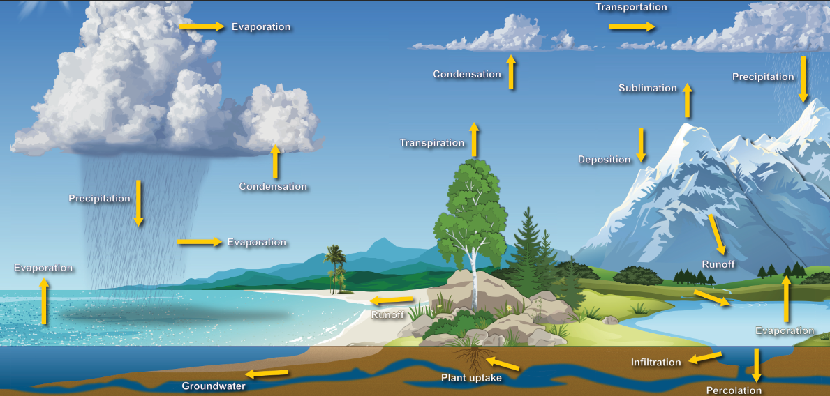
Figure 1: The Water Cycle. Source: National Oceanic and Atmospheric Administration (2025).
In the context of climate change, drought has become a pressing global issue. Rising global temperatures have intensified the hydrological cycle, altering precipitation patterns and increasing the frequency, duration, and severity of drought events. These changes heighten vulnerabilities in the Pacific Northwest (PNW), a region historically characterized by a temperate climate but increasingly affected by extreme drought conditions (Figure 2). As noted by Dai (2013) and Ebi (2022), the PNW is at significant risk of persistent drought due to a combination of climatic and environmental factors, including reduced snowpack, earlier snowmelt, and shifts in seasonal rainfall patterns. Addressing these drought-related challenges requires One Health focus, which recognizes the interconnectedness of environmental conditions, public health, and policy. Prolonged drought can degrade air and water quality and increase the risk of respiratory and heat-related illnesses—conditions that demand collaboration across environmental science, health care, and public policy sectors. Building climate resilience through integrated planning and cross-sector partnerships is essential to protecting both human and ecosystem health in the face of growing drought threats.
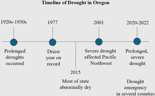
Figure 2: Timeline of Major Drought Events in Oregon. Created by Taylor West, using data from California Department of Water Resources (1978), Oregon Water Resources Department (n.d.) and the National Integrated Drought Information System historical drought data and Oregon drought data (n.d.).
Drought in Oregon: 2021 Overview
By the end of 2015, both Oregon and Washington states were already experiencing drought or abnormally dry conditions, which persisted for several years. By 2021, Oregon faced one of its most severe drought years in recent history. Approximately 95% of the state was classified as being in "severe drought" or worse, with large portions of eastern and southern Oregon facing "exceptional drought" conditions. These prolonged drought conditions exacerbated water shortages, reduced agricultural productivity, and created the ideal environment for large-scale wildfires.
The Role of Wildfire in Air Quality Degradation
The maps were created using PM2.5–fine inhalable air pollution particles smaller than 2.5 micrometers concentration data which pose serious health risks data from the Environmental Protection Agency (EPA), aerosol optical depth (AOD) data from the National Aeronautics and Space Administration's (NASA) moderate resolution imaging spectroradiometer (MODIS), and the Centers for Disease Control and Prevention's (CDC) National Environmental Public Health Tracking tool (https://ephtracking.cdc.gov/) presented to provide a visual representation of the intersection between drought conditions, particulate matter (PM) pollution, and air quality risks (Figure 3). Based on my research, counties such as Lane, Union, Jackson, and Harney experienced pronounced drought conditions in 2021, as indicated by the Standardized Precipitation Evapotranspiration Index (SPEI) falling below -0.5. These counties were also among the most impacted by wildfire activity during the summer and fall of 2021, with large fires burning hundreds of thousands of acres across the state. Wildfires, fueled by extreme drought, were a major contributor to elevated levels of PM2.5 in the atmosphere.
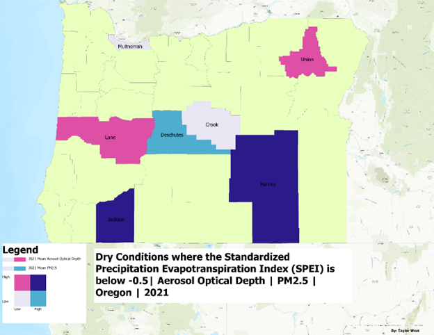
Figure 3: Spatial Relationship Between Drought Conditions, PM2.5 Pollution, and Public Health Risk in Oregon, 2021. Created by Taylor West, using Aerosol Optical Depth from NASA's MODIS product, EPA PM2.5 concentrations, and the Standardized Precipitation Evapotranspiration Index (SPEI) from California Merced.
Health Risks Associated with Poor Air Quality
Exposure to airborne particles (PM2.5), can penetrate deep into the lungs and enter the bloodstream, and poses serious risks to respiratory and cardiovascular health such as reduced lung function, aggravated respiratory diseases, increased hospital admissions, and even premature death. Among these health concerns, asthma—a chronic respiratory condition marked by airway inflammation and constriction—serves as a critical indicator of sensitivity to air pollution. Asthma symptoms can be significantly worsened by PM2.5 exposure, leading to acute exacerbations and an increased need for medical care. The age-adjusted prevalence of current asthma among adults aged 18 and older in Oregon counties map for the year 2021 provides estimates of how many adults currently have asthma, with adjustments made for age differences across populations to allow fair comparisons between counties (Figure 4). This county-level data helps identify local patterns and disparities in asthma prevalence, supporting public health planning and environmental health research.
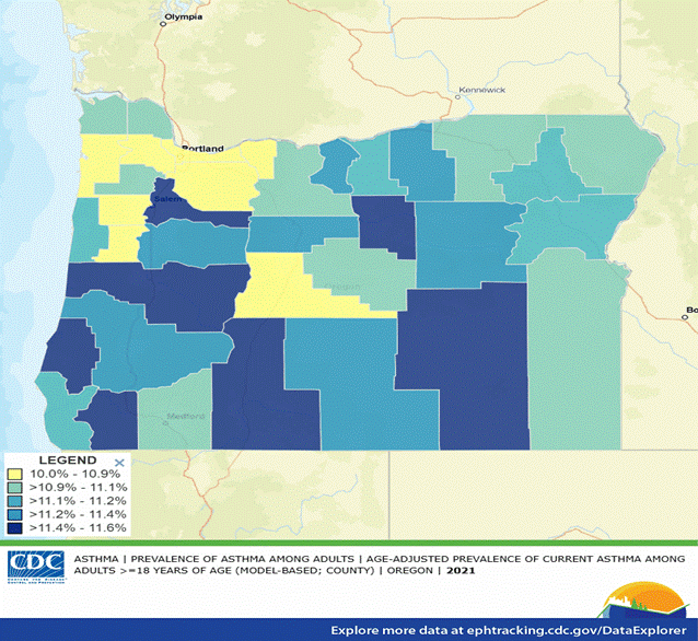
Figure 4: Asthma prevalence data (2021) for Oregon counties from the CDC's National Environmental Health Tracking tool.
In Oregon, the 2021 prevalence of asthma among adults reflects this risk, particularly in county's like Lane, Union, and Jackson, which experienced both severe drought and elevated PM2.5 concentrations. These counties reported asthma prevalence rates exceeding 11.2%, highlighting the compounding effect of environmental stressors on respiratory health. Vulnerable populations—including children, older adults, individuals with pre-existing respiratory or cardiovascular conditions, and communities of color—are disproportionately impacted due to structural health disparities and unequal access to care (American Lung Association, 2023). In rural areas where healthcare infrastructure is limited, individuals may face delays in receiving treatment, further elevating their risk of adverse health outcomes related to poor air quality.
Monitoring Air Quality: Gaps and Opportunities
Monitoring air quality during drought and wildfire events is essential for mitigating public health risks. The integration of ground-based observations from the Environmental Protection Agency's (EPA) Air Quality System (AQS) with satellite-based remote sensing technologies offers a promising solution. While ground monitors provide highly accurate, localized data, they are often limited in spatial coverage. In contrast, satellite product platforms such as the Geostationary Operational Environmental Satellite - Advanced Baseline Imager (GOES-ABI) offer large-scale, near-real-time observations of surface-level PM2.5 concentrations which provide timely data on fine particulate pollution at ground level, enabling rapid public health responses, air quality forecasting, and environmental monitoring during events such as wildfires or pollution spikes. Geostationary satellite instruments such as GOES-ABI have the capability to identify pollution hotspots and track the movement of particulate matter, especially when used in conjunction with polar-orbiting satellites (Zhang et al., 2022; O’Dell et al., 2024). For example, during the 2021 Bootleg Fire in southern Oregon, data from the VIIRS (Visible Infrared Imaging Radiometer Suite) satellite system was used to track massive smoke plumes and estimate surface-level PM2.5 concentrations in near-real time, helping to identify pollution hotspots across the PNW and informing air quality alerts for communities downwind (Figure 5).
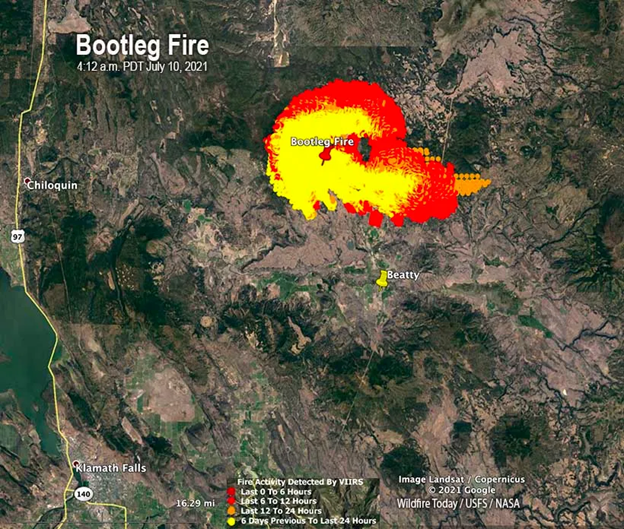
Figure 5: Bootleg Fire in Southern Oregon. Source: Adapted from Gabbert (2021).
Conclusion
The interplay between drought conditions, wildfire activity, air quality, and public health highlights the urgent need for comprehensive monitoring and intervention strategies. The 2021 drought in Oregon underscored the devastating effects of extreme drought-fueled wildfires, which led to hazardous air quality and heightened health risks, particularly for vulnerable populations. Without coordinated action, the region faces escalating consequences, including increased rates of respiratory illness, strain on healthcare systems, and widening health disparities rooted in environmental injustice. As the PNW continues to confront intensifying climate-related threats, integrating advanced monitoring technologies with proactive public health responses is essential.
These complex, overlapping challenges call for an approach that recognizes the interdependence of human and environmental health. By fostering interdisciplinary partnerships among environmental scientists, healthcare providers, public health officials, and policymakers, we can develop holistic strategies that address the root causes and cascading effects of climate change. Failure to act will not only endanger public health but also deepen existing inequities. Addressing these challenges through this lens is critical to building resilience and securing a healthier, more equitable future for all communities.
References
American Lung Association. (2023, November 2). Disparities in the impact of air pollution. Lung.org. Retrieved April 3, 2025, from https://www.lung.org/clean-air/outdoors/who-is-at-risk/disparities
Dai, A. (2013). Increasing drought under global warming in observations and models. Nature Climate Change, 3(1), 52–58. https://doi.org/10.1038/nclimate1633
Ebi, K. L. (2022). Methods for quantifying, projecting, and managing the health risks of climate change. NEJM Evidence, 1(8). https://doi.org/10.1056/evidra2200002
O'Dell, K., Kondragunta, S., Zhang, H., Goldberg, D. L., Kerr, G. H., Wei, Z., Henderson, B. H., and Anenberg, S. C. (2024). Public health benefits from improved identification of severe air pollution events with geostationary satellite data. GeoHealth, 8, e2023GH000890. https://doi.org/10.1029/2023GH000890
Trenberth, K. E., Dai, A., Van Der Schrier, G., Jones, P. D., Barichivich, J., Briffa, K. R., and Sheffield, J. (2014). Global warming and changes in drought. Nature Climate Change, 4(1), 17–22.
Zhang, H., Wei, Z., Henderson, B. H., Anenberg, S. C., O'Dell, K., and Kondragunta, S. (2022). Nowcasting applications of geostationary satellite hourly surface PM2.5 data. Weather and Forecasting, 37(12), 2313–2329. https://doi.org/10.1175/WAF-D-22-0114.1
More Articles in this Issue